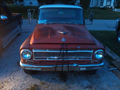
So I noticed a sinkhole on a satellite image and hiked to it yesterday. A 2.5 easy hike from the nearest paved road out in the middle of nowhere north of Flagstaff about 25 miles. That’s what I did yesterday. Near Wupatki National Monument is you know the area. The sinkhole was about 100 feet deep with no way inside that I woulda liked to try. The bottom was full of tumbleweeds. Who knows how deep the tumbleweeds are. In spots, maybe 20 feet deep. It woulda been cool to see the bottom before the tumble weeds came to the West about a 100 years ago as they were an invasive species that came from Russia. Mighta seen bones and possible Native American artifacts down at the bottom. Tumble weeds are officially called Russian Thistle by the way.
Brought a rifle in case I came across a coyote as the antelope will be having their young soon and want to help the declining antelope population. Didn’t see a coyote or antelope. Only cut one antelope track about a week old.
Here are some pictures of the sinkhole. One with some pottery shred. I am technically challenged so don’t know how to properly insert them photos. Sorry about that.
"Successful is leaving something in better shape than you inherited it in. Keep that in mind, son." Dad
Interesting. Southern Idaho is largely volcanic. There are lots of these holes out in the lava beds although not as deep as that. Most of these are collapsed lava tubes.
I agree about the tumbleweeds. We've been seeing a lot more Russian thistle the last 10 years or so. It's really spreading. People often call mustard tumbleweeds but that isn't the same thing. Between the thistle and cheat grass, our ranges are really taking a serious hit.
“In a time of deceit telling the truth is a revolutionary act.” ― George Orwell
It's not over when you lose. It's over when you quit.
Cool. We have them in northeast Iowa. Most of them are full of rattle snakes and old junked cars.
kwg
For liberals and anarchists, power and control is opium, selling envy is the fastest and easiest way to get it. TRR. American conservative. Never trust a white liberal. Malcom X Current NRA member.
It’s all limestone in the area. Not much dirt cover on top of the limestone
The hole is pretty much vertical all the way around it. One wall was solid limestone, the other sides were fractured limestone. The vertical wall was at least 100 feet deep, the other fractured rock sides were say 50. It’s kinda on a slope.
"Successful is leaving something in better shape than you inherited it in. Keep that in mind, son." Dad
maybe there's different varieties of limestone but around here limestone is white looks more like a variety of sandstone in the picture but without being there it's really hard to tell
It's limestone. Kaibab Limestone. Flagstaff knows his rocks. this is displacement along the east kaibab monocline runs all the way from Chavez pass up into Ut. Makes up eastern edge of Gray Mountain, the kaibab Plateau, and the cockscomb in southern UT, and even cottonwood Canyon on the way to Bryce.
One of the members in Kaibab Formation has a lot of gypsum that dissolves out and forms sink holes. They are all over the north kaibab (unit 12)
Being on the hinge of the monocline (flexure point) allows even more surface water in to dissolve the gypsum.
Well, I'd look for something shallower as I'd not like to climb down that to butcher a buffalo or 16 and I doubt I'd like carrying buffalo pieces up out of there.
The desert is a true treasure for him who seeks refuge from men and the evil of men. In it is contentment In it is death and all you seek (Quoted from "The Bleeding of the Stone" Ibrahim Al-Koni)